Safari Planning
A guide to planning your safari to the Okavango Delta
Read More
The Okavango Delta is formed when a great river flows not into the sea – but into the Kalahari desert in the middle of the southern African continental landmass. The formation of the Okavango Delta is an extraordinary natural phenomenon, an 18,000 sq kilometre wetland forms like an oasis in the desert of Northern Botswana, forming a sanctuary to the largest populations of wildlife in Africa.
The Okavango Delta is in fact more correctly termed an alluvial fan comprising areas that are permanently, seasonally and occasionally flooded. It is this seasonal nature of the Okavango which creates such a rich and diverse habitat for its wildlife.
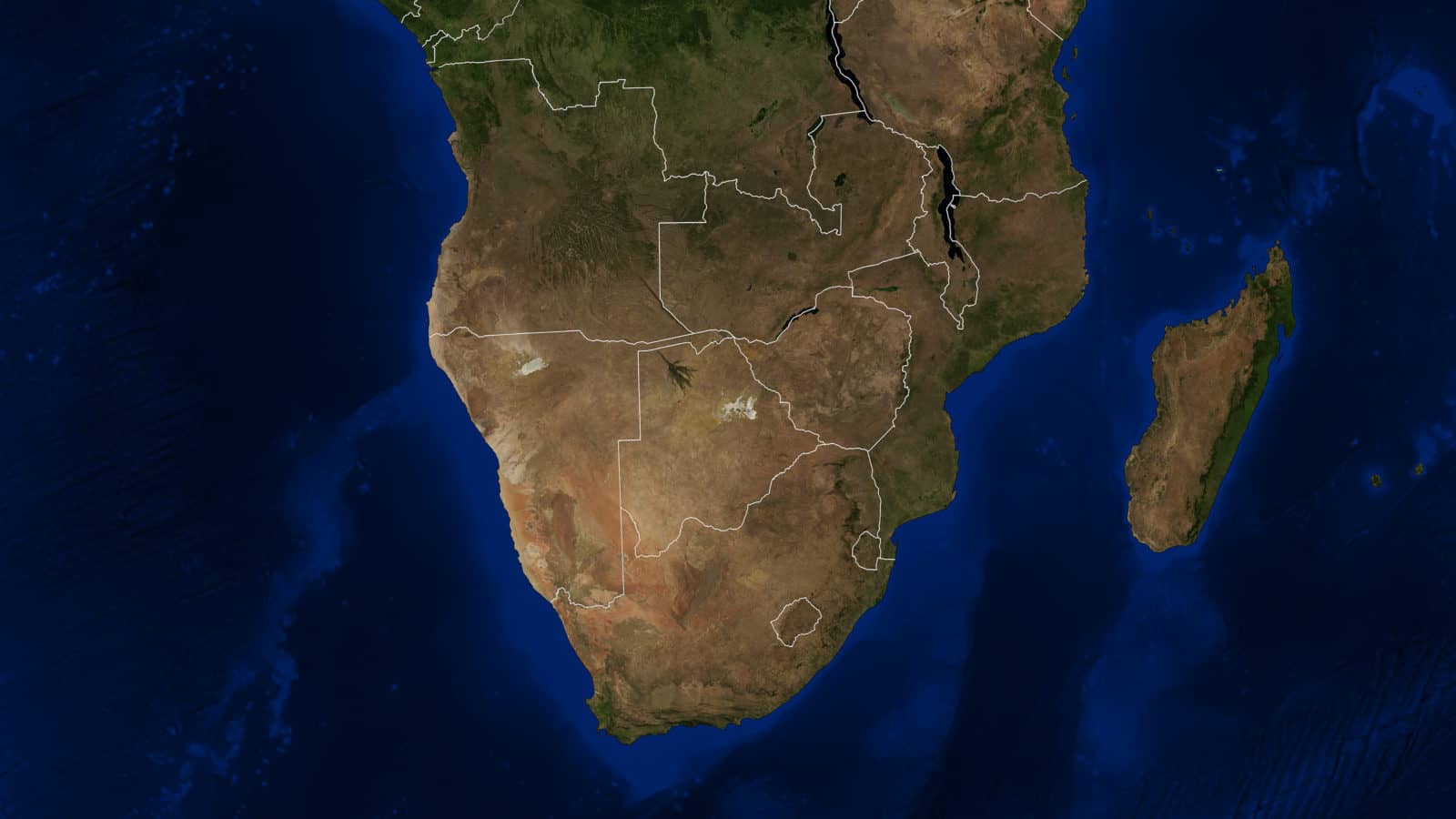
The Okavango Delta is the culmination of a river system that has its catchment areas in Angola, flows through Namibia and then into Botswana where various processes govern the distribution across the alluvial fan. The source of the Okavango Delta lies in the Planalto highlands in Angola, 1,100 km away. A number of small tributaries gather to form the Cuito River which flows south to Namibia, joining the Cubango River where it gains considerable momentum and breadth to become the Okavango River in Botswana. The source in the Angola highlands lies at 1200 metres above sea level and flows towards the Okavango which has an altitude of 1,000 metres above sea level at the top of the panhandle to 930m in the basin.
The flow and shape of the Okavango Delta has both a physical and biological factors. The physical conditions are dependent on slope, sedimentation, faults and channels carved long ago in the Kalahari sands. The biological process includes the shaping of channels by hippopotami pushing their way along the waterways, termites constructing their intricate mounds and the natural growth of papyrus. With so many factors at play in the formation of the Okavango Delta, it is not surprising that the flow of water is variable and unpredictable.
The Delta consists of a multitude of main channels, smaller tributaries and lagoons as well as floodplains, islands and mainland areas. The watercourses are always changing due to annual flooding as well as a combination of sediment transport, seismic activity, the construction of termite mounds, the continual opening up of new channels by feeding hippopotami and the closing of others by new vegetation growth.
The central area of the Kalahari was once a vast lake, Lake Makgadikgadi. The Delta is the final watery reminder of this great lake; the wonderous Makgadikgadi salt pans are the exposed and dry lake bed. Experts believe that the Kwando, Linyanti, Chobe swamps and rivers and the Upper Zambezi once flowed as one vast river and joined the Limpopo River and flowed into the Indian Ocean.
The flow and shape of the Delta is in part caused by geological fault lines. These fault lines were created about two million years ago during tectonic activity of the Great East African Rift Valley. Rifting of this area caused the uplift and collapse of the area, resulting in the lowest area in the whole Kalahari, the Delta and Makgadikgadi Pans.
There is a series of parallel fault lines north of the Delta which direct the Okavango, Cuito, Kwando and Zambezi rivers to the south-east. The Gumare fault separates the Panhandle from the Delta and the Linyanti fault causes the Kwando River to divert into the Linyanti Swamps, which are a great wildlife viewing area and a mini-delta in themselves.
Further fault lines along the Rift Valley extension dictate the dispersal of the water: the Thamalakane fault results in Maun’s Thamalakane River and prevents the spreading of the Delta beyond Maun to the south-east. To the north, the Chobe fault creates the Chobe River which is in fact a backwater of the Zambezi River and flows in two directions. The Okavango and the Chobe system are in fact still connected via the Selinda Spillway, although recent years have been to dry to cause the Spillway to flow. Effectively then, the rifting of these extensions of the Great Rift caused a backing up of the flow of water which resulted in the vast myriad of swamp networks of the Delta and Linyanti.
What makes the Okavango unique is the fact that it is a freshwater alluvial fan. Most interior drainage systems (rivers that do not reach the sea) are saline because the only outlet for the water is via evaporation which leaves salts, such as in the Makgadikgadi Pan. However, the Okavango Delta has outlets west to Lake Ngami and to the east via the Boteti River which ends in the Makgadikgadi Pan. Although only three percent of the Okavango’s inflow actually flows out via these outlets, this is enough to keep the Delta freshwater rather than saline.
Part of the answer to the formation of the Okavango Delta lies in the geological history and the story and effect of the fault lines that are described above. Another vital component is the effect of silt and sediment carried by the river. The Okavango River has over the years carried millions of tonnes of sediment which it then deposited as it seeped out over the flatness of the Kalahari. The Kalahari Basin is in fact so flat precisely because the basin has been filled with sediments over the last 65 million years. The sediments are several hundred metres deep in places and the Delta in particular sits on between 100 and 270 metres of deposits. The deposits were originally made by the vast single river described above and in the much drier last two million years deposits have been of wind-blown sand.
The river borne deposits created the channels and ultimately the fan shape of the Delta and the river still continues to drop the load that it carries from the Angolan Highlands, blocking channels and forcing the water to take no routes and thus changing the shape of the Delta to this day.
Growth of papyrus also blocks channels and re-routes the water to create the Delta’s characteristic maze of waterways and the action of hippopotami in pushing through and opening channels helps to keep the water flowing and the channels intact and also creates new channels.
A final aspect that continues to shape the Delta is tectonic shifts which happen frequently in the area. Even tiny shifts can have a significant effect on flow and distribution of water in such an otherwise flat area.
The formation of the Okavango Delta islands is a fascinating illustration of the interrelationship of geomorphological and hydrological factors and also the effects of living creatures. There are three basic types of island.
The first are the long, ribbon-like islands which are created when channels silt up and become higher than the surrounding floodplain. As water diverts around the deposited sediment, an island is formed and is gradually populated by trees seeded by birds’, elephants and other mammals’ droppings. The eventual forest and grazing opportunities provided by these ‘long’ islands make the Delta the sanctuary for the multitude of magnificent wildlife: buffalo, elephant, antelope, leopard, waterbuck and more that are drawn to and protected by the inaccessibility of this unique Eden.
The second type of islands are ‘round’ islands which are found throughout the delta and play fundamental role in the formation of the Okavango Delta. These are circular and smaller than the sinuous ‘long’ islands and extraordinarily each one begins with a humble termite mound. The termite mound becomes colonised by a tree which grows from seed deposited in animal droppings. The islands’ trees are characterised by wild date palm (phoenix reclinata) and, on the bigger islands, real-fan palms (hyphanae petersiana) and jackalberry (diospyros mespiliformis). Fascinatingly, the transpiration of the trees actually ends up killing life on these islands. The centre becomes white and barren as the levels of white, salty substance called troma builds up as plants suck up water from the islands but leave salts behind, ultimately making the islands toxic and incapable of sustaining vegetation, apart from the hardy spike grass (sporoblus spicatus) and on the outer, less toxic edges, couch grass (cynodont dactylon).
Chief’s Island is the largest island in the Okavango Delta and it and the other largest islands are a third type of island which is created by tectonic shifts raising land. Chief’s Island is abundant in wildlife including the large mammals: buffalo, lion, elephant, zebra, chacma baboon and others which enjoy the mix of habitats ranging from riverine woodland to open grassland.
Nutrients in the Delta
The Delta as we see it now, bounded by the Thamalakane fault, might only be 120,000 years old because large areas of alluvial deposits have been discovered to the south and east of its present extent which is evidence that water flowed previously far beyond the current limits of the Delta’s fan. Prior to the formation of the Okavango Delta the river flowed through northern Botswana into the super lake of Lake Makgadikgadi.
Over the last million years there have also been larger patterns of drying in which the Delta shrank and of times of heavy flood when the channels might have combined into one river and flowed out into the mega lake of Lake Makgadikgadi. Northern Botswana and the Delta has therefore taken many differing appearances over the last millennium; at times it would have looked much drier and more like the Namib Desert and at other times it would have been far wetter with vast lakes covering the Makgadikgadi and Lake Ngami areas.
Those interested in the formation of the Okavango Delta may enjoy the National Geographic documentary Into the Okavango, which records an expedition to locate the source of the Okavango through to its end in the Kalahari.
The great thirst into which the Okavango River flows.
The Kalahari Desert is a large semi-arid sandy savannah in Southern Africa extending 900,000 square kilometres (350,000 sq mi), covering much of Botswana and parts of Namibia and South Africa.
As semi-desert, with huge tracts of excellent grazing after good rains, the Kalahari supports more animals and plants than a true desert, such as the Namib Desert to the west.
The Kalahari Desert is formed in one of the earth’s areas of high pressure (or Hadley Cells) known as the “horse latitudes”. The horse latitudes sit at about 30 degrees latitude and they are especially dry. This is because warm, moist air rises at the equator where solar rays are most intense and the moisture then falls as rain, resulting in high levels of rainfall in the tropics. The now dry air rises and moves away from the equator. At 30 degrees it falls and heats and expands as it falls.
This phenomenon results in constant high-pressure systems that drive away rain and is why the deserts of the world, including the Kalahari, sit in the 30 degree or “horse latitudes”. Another factor is the continentality of the Kalahari, or its distance from the sea. Proximity to the seas results in rainfall due to evaporation from the sea and consequent precipitation but the Kalahari is in the centre of the African continental land mass. The cause of the Namib desert is different and is the cold Benguela current in the Atlantic ocean.
The surrounding Kalahari Basin covers over 2,500,000 square kilometres (970,000 sq mi) extending farther into Botswana, Namibia and South Africa, and encroaching into parts of Angola, Zambia and Zimbabwe. The Okavango Delta is at the centre and the lowest point of the Kalahari Basin. The Okavango River is the only permanent river in the Kalahari region.
The Okavango flows into a Delta in the northwest, forming marshes that are rich in wildlife. Ancient dry riverbeds—called omuramba—traverse the central northern reaches of the Kalahari Desert and provide standing pools of water during the rainy season. Previously havens for wild animals from elephants to giraffes, and for predators such as lions and cheetahs, the riverbeds are now mostly grazing spots, though leopards and cheetahs can still be found. Among deserts of the southern hemisphere the Kalahari Desert most closely resembles some Australian deserts in its latitude and its mode of formation.
The Kalahari receives small amounts of rainfall and the summer temperature is very high. It usually receives 3–7.5 inches (76–190 mm) of rain per year. The Delta is a miraculous presence in the Kalahari ‘thirstlands’, where annual evaporation rates are five times that of rainfall. This means that, without the Delta, there would be no surface water for seven months a year.
Contact us for more information and to start planning your Okavango safari
Contact